Possible routes for the canal was surveyed in 1726 by Alexander Gordon and in 1762 by Robert Mackell and James Murray. These provided the basis for John Smeaton`s plan of 1764 and he suggested two possible routes, one of which was from the Yoker Burn at Glasgow to the River Carron on the Forth. He estimated the 1.5m (5 feet) deep, 43km (27 mile) long canal would cost around £79,000.
The political intrigue started: Glasgow tobacco merchants were angry at it bypassing the city, the influential Carron Iron Company supported it because its eastern terminus was handy for them, and various landowners along the route sought to use the canal to increase their own wealth. There were also battles between various interests in Glasgow and Edinburgh and the language used in today's `boisterous` rivalry between the two cities pales into insignificance compared to one letter to the press which stated that `Edinburgh, Sir, is the metropolis of this ancient kingdom, the seat of Law, the rendezvous of Politeness, the abode of Taste, and the winter quarters of all our nobility who cannot afford to live in London; and for these and other reasons equally cogent Edinburgh ought to have the lead upon all occasions. The fools of the west must wait for the Wise Men of the East.` To complicate matters even further, there was also great disquiet over the power held by London-based financial interests. Some things never change!
This article is based on the guidebook "The Glasgow Guide".
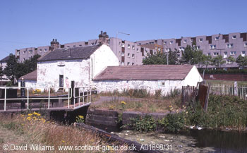
The canal passes through the district of Maryhill, much of whose development depended on the success of the canal.
There is a series of five locks in Maryhill and this is Lock 21 which is at the highest point on the canal. The white building behind is the White House Inn, one of the original canal inns.